The Qanat Doctrine
Iran’s 3,000-Year Architecture of Survival
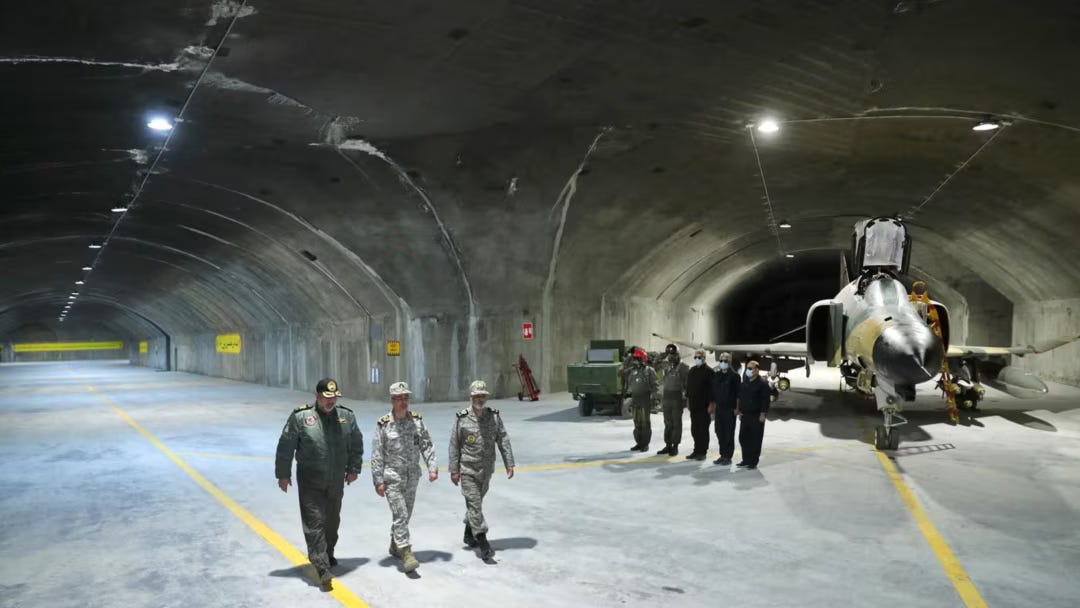
Somewhere beneath the city of Gonabad, in eastern Iran, water that fell as rain on a mountain range three thousand years ago is still moving. It travels through a tunnel 33 kilometers long, cut by hand into the earth, descending at a gradient so precisely calibrated that it flows without stagnating and without eroding the walls. The tunnel has survived the Macedonian conquest, the Arab armies, the Mongol destruction, the Safavid wars, the Qajar decline, the British-Russian partition, the Pahlavi modernization, and the Islamic Republic. It survived all of them for the same reason: nobody can destroy what they cannot find, and what they cannot find, they cannot stop.
This is not a water management story.
What Persia Understood Before Everyone Else
The people who built the Gonabad qanat were not primitive engineers improvising in desert sand. They were specialists: the muqqanis, a hereditary class of craftsmen who carried in their hands the knowledge of geology, hydrology, and subterranean navigation that no written text could fully encode. To build a qanat, a muqqani first had to read a mountain: identify the aquifer at its base, calculate the groundwater table depth, determine the precise angle of descent that would keep the water moving without destroying the channel. Then he would begin at the far end, the delivery point, and work backward into the earth, sinking vertical access shafts at intervals to remove spoil and provide air to the diggers working below. The shafts appear from above as a line of circular craters crossing the desert, looking like nothing in particular, giving nothing away about what moves beneath them.
The angle of the tunnel had to be steep enough to permit flow but shallow enough to prevent the current from accelerating into erosion. The muqqani was performing civil engineering calculations before the discipline had a name, using tools of wood and rope, working by touch and accumulated knowledge, across tunnels that ran forty miles through solid rock. When Greek historian Polybius encountered a qanat in the second century BCE, he wrote that the Persians were “mysteriously bringing water from the depth of the earth to the surface,” and that those who used the water downstream did not know where it came from. He was recording this with barely concealed wonder. To the engineers who built it, the concealment of the source was not an incidental feature. It was the design.
The UNESCO designation in 2016 registered eleven Iranian qanats as World Heritage Sites and called the plateau they irrigated a “Qanat Civilization.” Iranian desert cities that should not exist do exist, because the water that feeds them was placed underground and kept there, invisible to drought, invisible to invasion, invisible to time.
What the qanat encoded was a strategic philosophy in the language of engineering. The vital resource goes underground. It is distributed, not centralized: hundreds of separate systems, each one independent, with no single node whose destruction kills the whole network. The access points are indistinguishable from ordinary landscape features. The knowledge of the system is carried in the hands and eyes of the people who maintain it, not recorded in documents that a conquering army could seize. To destroy the water supply of a qanat city, you would need to find every shaft, collapse every tunnel, and do it faster than the muqqanis could repair the damage. No invader ever managed it.
The Underground as System
The qanat was the foundation of a comprehensive Persian subsurface architecture that extended into climate control, food preservation, and urban design, each element reinforcing the others.
The yakhchal took the logic of underground water and applied it to cold. In the Dasht-e Lut and Dasht-e Kavir, two of the hottest desert systems on earth, Persian engineers built domed refrigeration structures whose function lived beneath the visible dome: a subterranean chamber several meters deep, built from sarooj, a mortar of sand, clay, egg whites, lime, goat hair, and ash, with walls two meters thick at the base. At night in winter, water was channeled from nearby qanats into shallow pools adjacent to the structure; by morning it had frozen; the ice was cut into blocks and sealed underground. Shade walls ten to fifteen meters high, built running east-west, blocked solar radiation from the pools and bought workers time to harvest ice each morning before the sun reached them. Ice stored in winter survived intact into late summer, in a desert where the surface temperature reached fifty degrees. No energy input. No machine. No single point of failure.
The badgir, the Persian wind tower, completed the system. It is a tall chimney-like structure built above a building, catching prevailing winds at height and directing them downward through internal shafts. In configurations that used both technologies together, the descending air passed over underground qanat channels before entering inhabited rooms, arriving as refrigerated air in a desert house in the middle of the afternoon. The windcatcher of Dowlatabad Garden in Yazd still stands 34 meters above the desert floor, still functional, still cooling the space beneath it. These devices were operating in Achaemenid architecture before the fifth century BCE. The Romans had underfloor heating. The Persians had integrated passive cooling systems drawing on underground water and channeled wind, sustaining comfortable indoor environments in one of the harshest climates on earth, without a single external energy input.
The Shushtar Historical Hydraulic System scaled all of this to the level of a city. Inscribed by UNESCO as a masterpiece of creative genius, it traces its origins to Darius the Great in the fifth century BCE. Two main diversion canals were cut from the Karun River, one of which, the Gargar canal, still delivers water to Shushtar today through underground tunnels feeding mills, irrigation, and domestic supply. French archaeologist Jane Dieulafoy, writing from her travels, called it the largest industrial complex in the world before the Industrial Revolution. Shapur the Great expanded it in the third century CE using Roman prisoners captured at the Battle of Edessa in 260, when he defeated and captured the Roman Emperor Valerian, the only Roman emperor ever taken prisoner by a foreign power, and set him and his engineers to digging Persian canals. The system ran dams, bridges, fifty watermills, irrigation channels across 40,000 hectares of farmland, and a defensive moat around the city from a single hydraulic design that remains, in most of its elements, operational today. Water management and military protection were the same infrastructure. They were always the same infrastructure.
Ouyi: The City That Disappeared
Five kilometers north of Kashan, in the small desert town of Nushabad, the inhabitants of the Sassanid Empire built something that no other ancient civilization is known to have built on this scale: a complete city underground.
Ouyi was constructed during the Sassanid period, roughly 1,500 years ago, and expanded across the following centuries through the Seljuk, Safavid, and Qajar eras. Its existence was entirely unknown until the early 2000s, when a resident digging a sewage pit in his courtyard broke through the ceiling of a tunnel and fell into a corridor below. What archaeological excavation then revealed across four square kilometers beneath Nushabad was a labyrinth of corridors, chambers, ventilation shafts, water channels, food storage rooms, toilets, places of worship, and booby traps, arranged across three underground levels descending to 18 meters below the surface.
The design was not improvised. The corridor entrances were sized for one standing adult and concealed inside private houses: beneath ovens, beneath stable floors, behind false walls. Each family had its own chamber off a shared tunnel. The ventilation shafts were cut in L and U shapes to prevent the enemy from following airflow lines to the population below. The passages curved continuously, eliminating sightlines and creating ambush points at every turn. Deep pits were dug in the middle of rooms and covered with rotating stones calibrated to hold the weight of a known inhabitant but collapse under the different weight distribution of an intruder in full armor. Oil lamp niches were cut into the walls at one-meter intervals. The last person in a retreating group would extinguish each lamp behind them, leaving pursuers in absolute darkness in a maze they did not know.
The city could sustain its entire population underground for days. Food stores, cold rooms for preservation, water channels, ventilation, sanitation: all present. The surface above could be occupied, searched, burned. When the Mongols came, they found the houses warm and the lamps alight. The local historical account describes their bewilderment: the soldiers entered the streets, moved through the houses, found the hearths still warm, and could not find the people. The sudden disappearance broke the attackers’ spirit. It was not a miraculous vanishing. It was a city that had been underground for generations, waiting.
Ouyi is the direct ancestor of the missile cities. Not metaphorically. Structurally. Multiple concealed entrances inside civilian infrastructure. Three levels of depth to absorb escalating attacker capability. Ventilation engineered to support life and activity at depth. A population, or an arsenal, that vanishes below the surface and keeps functioning while the surface absorbs whatever is coming. The IRGC engineers who built the first missile base in 1984 were not reading Ouyi as inspiration. They were drawing on the same civilizational logic that produced Ouyi, the qanat, the yakhchal, and Shushtar, the same logic that Persian geography and Persian history had encoded across three millennia: take what must survive and put it where the enemy cannot follow.
The Transfer: Desert Engineering Meets Desert War
In the summer of 1984, Iraqi Scud missiles began landing in Iranian cities. The Iran-Iraq War had entered its phase of urban terror: Saddam Hussein, supplied with Western intelligence and Gulf financing, was demonstrating that the Iranian interior was not safe. Iran’s surface air defenses were degraded. Its air force, gutted by the post-revolution purges of trained pilots and the spare-parts embargo, could not dominate the sky. The adversary had satellite targeting. The surface was lethal.
That year, Iran obtained its first ballistic missiles from Libya. That same year, the first underground missile base was constructed.
The timing is not coincidental. It is civilizational. When the Islamic Republic’s engineers faced the question of how to survive a modern air war with a degraded force and an adversary with Western intelligence feeding his targeting, they reached for the answer that Persian engineering history had been refining for three thousand years: take the vital asset underground, distribute it across the landscape, eliminate the single point of failure, let the surface absorb whatever comes. What the IRGC built over the following four decades is one of the most ambitious subterranean military construction programs in human history.
The Missile Cities
The geography cooperated with the construction. More than half of Iran is mountainous terrain. The Zagros range, stretching across western Iran, is composed mainly of limestone, dolomites, and sandstone, sedimentary formations that fold naturally into crevices and cavities, reducing the excavation required to create tunnel space. The Alborz range to the north provides the same architecture. The mountains are already folded; the IRGC engineer reads the fold, identifies what the geology offers, and deepens it. The muqqani read the aquifer at the mountain’s base. The IRGC engineer reads the mountain’s interior. The method is identical.
Underground missile bases exist, according to Iranian authorities, in all provinces and cities of Iran. They reach depths of up to 500 meters. Each base has multiple entrances spaced hundreds to thousands of meters apart along the mountain face, separated by tunnel gates. Destroying one entrance traps no missiles, because the network inside the mountain connects through all the others. Hajizadeh said in 2015: “If we unveil a missile city every week for the next two years, it will still not be finished.” Analysis of footage across multiple unveilings confirms distinct facilities with different tunnel geometries and different inventories. The IRGC’s second-in-command stated the following year that Iran’s depots were so full it did not know where to store new missiles. This is not a single bunker with a large arsenal. It is a distributed network of independent facilities, each separately constructed, separately supplied, with no command node whose destruction collapses the others.
The design eliminates the surface events that satellite reconnaissance is built to detect. Conventional missile launches require visible launch pads, erectors, and fuel trucks, detectable days in advance. Iran eliminated this. Missiles are stored in vertical cylindrical magazines built inside tunnels, positioned for launch through concealed hatches covered with soil. The solid-fuel missiles in the newer inventory require no fueling cycle before launch. No thermal signature. No pre-launch surface activity. The missile goes from stored to airborne without a single visible event. Some tunnel sections are large enough to fire four or five missiles simultaneously.
The qanat shafts spaced across the desert, each one a ventilation and access point, none of them the channel itself, the channel living deeper and moving continuously: that is the design these facilities are running.
The Nuclear Underground
Fordow was built in secret starting in 2006. Its existence was disclosed to the IAEA only in September 2009, after Western intelligence had already identified it, three years into construction. The facility sits near Qom inside a mountain. The site is embedded in limestone and metamorphic rock, both selected with the same geological deliberateness the IRGC applies across its underground program. Limestone and metamorphic rock absorb blast energy through deformation rather than fracture. The facility is not beneath the mountain in the sense of a basement under a building. It is inside the mountain: the rock is the structure.
What makes Fordow’s institutional history significant is that it began as an IRGC missile base before its conversion to uranium enrichment. The IRGC dug the cavity for military storage, then adapted it as the nuclear program’s requirements changed. This is how the IRGC thinks about underground space: it is built for permanence, depth, and concealment. The function adapts to whatever the strategic situation requires. The cavity endures.
According to the Institute for Science and International Security, Fordow at declared capacity could produce enough weapons-grade uranium for nine nuclear bombs in approximately three weeks. That is the declared figure. In January 2023, an unannounced IAEA inspection found uranium enriched to 83.7 percent purity at the site, one step below weapons-grade, in centrifuge configurations that Iran had modified without informing the agency. The declared is not the whole picture. In Iran’s underground program, it never has been.
The new tunnels being excavated at Natanz, running into the Karkas Mountains through granite and gneiss, have shafts plunging over 100 meters deep, deeper than the original enrichment halls, which sit at roughly 20 meters. The construction accelerated after each strike. When the Natanz access infrastructure was damaged, spoil piles at the new tunnel construction site grew.
Eagle-44 and the Underground Air Force
In February 2023, Iran unveiled Eagle-44: the first publicly acknowledged underground air base, housing fighter aircraft inside tunnels carved into rock. The announcement was noted and largely filed as military theater. That is a serious error of categorization.
An underground air base is among the most demanding engineering projects imaginable. Aircraft require maintenance pits, fuel delivery infrastructure, weapons loading areas, spare parts storage, taxiway clearances, and ceiling heights sufficient for the airframe and tail assembly during movement. The ventilation requirements alone, given jet fuel vapor and engine exhaust at depth, require air circulation engineering of significant complexity. Eagle-44 provides all of this inside a mountain. The aircraft are invisible at rest. They have no above-ground flight line, no fuel depot, no maintenance apron showing on satellite imagery as a functioning military installation. They emerge when ordered.
The question Eagle-44 forces is not whether Iran has an underground air force. It is how many Eagle-44s there are that have not been announced. Iran does not disclose capabilities for transparency. It discloses them when the disclosure serves a strategic purpose, which means every unveiled facility implies a larger set of unveiled ones behind it.
Beneath Tehran
Five kilometers of tunnel run beneath the government quarter of central Tehran. The network sits 40 to 50 meters below the Shahid Shourideh Medical Center in the Pasteur district, a Ministry of Agriculture clinic that has operated above the complex since 1985. The medical facility was chosen for the same reason Ouyi’s entrances were placed beneath private ovens: an unremarkable civilian building at the surface attracts no scrutiny. The tunnel system extends northwest to an entrance near Rajabi Street, roughly 200 meters from the hospital, and east to a concealed access point beneath the Jami multi-story parking garage, adjacent to an elementary school.
Parking structures and schools above. Tunnel network below. Ordinary surface manifestations of underground systems that civilian life builds around without knowing. The Ouyi engineers placed their entrances in private homes. The IRGC placed theirs in public parking structures. The method is the same: the entrance should be indistinguishable from whatever the surface legitimately requires.
Under normal conditions, Tehran contractors excavate approximately 10 meters of tunnel per day. At that rate, building five kilometers takes a minimum of 500 consecutive working days. The infrastructure beneath the Pasteur district was planned across years, built in phases, concealed inside the operating fabric of a functioning city, and remained entirely unknown until the Israeli military published footage in March 2026 following strikes on the surrounding district. The city above was occupied and functioning for decades. The infrastructure below was running in parallel.
This is what the Sassanid builders of Ouyi understood 1,500 years ago: the surface city and the underground city can occupy the same coordinates, serve the same population, and remain invisible to each other until one of them is needed.
Pickaxe Mountain
Kuh-e Kolang Gaz La: Pickaxe Mountain. It sits one mile south of the Natanz nuclear facility in the Zagros range. Construction began around 2020. The IAEA has never been permitted to inspect it.
Satellite imagery from Planet Labs analyzed by the James Martin Center for Nonproliferation Studies shows four entrances carved into the mountainside, two to the east and two to the west. Each entrance is 6 meters wide and 8 meters tall. The spoil piles from excavation place the facility at a depth of between 80 and 100 meters, making it 10 to 20 meters deeper than Fordow.
The GBU-57A/B Massive Ordnance Penetrator weighs 13,600 kilograms. It is the largest conventional bomb the United States has built. It is designed to penetrate 60 meters of earth or up to 18 meters of reinforced concrete at standard 5,000 psi compressive strength before detonating. Against the higher-grade rock and concrete Iran uses in its underground construction, that effective penetration depth is significantly lower. B-2 stealth bombers dropped it on Fordow in June 2025. At 80 to 100 meters inside Zagros limestone, Pickaxe Mountain sits at or beyond what this weapon can reliably reach.
After the June 2025 strikes on Natanz and Fordow, the heavy equipment at Pickaxe Mountain did not stop. Dump trucks, trailers, and construction vehicles continued operating. Construction accelerated.
The strikes did not slow construction at the facility designed to survive what struck Fordow. They accelerated it. When one tunnel is damaged, you do not stop moving the water. You dig another. You go where the adversary’s weapon cannot follow.
The Civilizational Misread
The Western strategic framework for Iran’s underground program, since Fordow was disclosed in 2009, has treated the facilities as Iranian deception and nuclear provocation. That framing is not wrong. It is incomplete in a way that makes it useless for predicting Iranian behavior.
Iran’s underground architecture did not originate in the nuclear standoff. The first underground missile base was built in 1984, before Iran had a serious nuclear program, before the JCPOA, before Fordow, before Stuxnet. The impulse predates every specific strategic context Western analysts use to explain it. It is civilizational, which means it predates the Islamic Republic, the Pahlavi state, and the Qajar state. It predates Islam in Persia. It is the distilled institutional conclusion of a civilization that has survived every major conquering power of the past 2,500 years: Alexander, the Umayyads, the Abbasids, Genghis Khan, Timur, the Ottomans, the British, the Russians, and Saddam Hussein. Each conquest passed. The underground infrastructure continued.
Polybius wrote twenty-three centuries ago about a technology already ancient when he encountered it. He was not describing a hydraulic system. He was describing a civilization that had encoded, in stone and water and gradient, the principle that what cannot be seen cannot be stopped. The muqqanis who carried that knowledge in their hands were not defense contractors. They were craftsmen maintaining infrastructure. The principle they maintained was survival.
Iran is not building missile cities and underground nuclear facilities because the IRGC read a defense procurement manual. It is building them because Persian civilization arrived at a single conclusion long before the IRGC existed, and the IRGC read the landscape the way the muqqanis did: find what the geology offers, go deeper than the enemy can reach, distribute what must survive so that no single strike ends it, and let the surface take whatever comes.
The Open Shaft
The IAEA’s Rafael Grossi said, in March 2026, that he cannot verify where Iran’s stockpile of enriched uranium currently sits, because inspectors cannot access the facilities while hostilities continue. The stockpile before the war stood at approximately 9,250 kilograms. Some portion is at Fordow, which has sustained damage. Some is at Natanz, whose above-ground access points have been repeatedly struck. Some is at Isfahan. And some, possibly, is inside a mountain that four tunnel entrances and a spoil pile on a satellite image suggest exists, at a depth the largest conventional bomb in the US arsenal may not reliably reach, in a facility no inspector has ever entered.
That is the question the evidence leaves open. Not how much of Iran’s underground network has been struck. How much of it was built in the decade when attention was fixed on the nuclear deal, then the sanctions, then the deal’s collapse, then the diplomatic track that went nowhere. The muqqanis did not announce new qanats to the people who depended on the old ones.
They dug.


